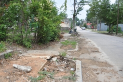
In keeping with the latest transportation changes, city officials are working to make Raleigh more pedestrian friendly and encouraging residents to take to the sidewalks.
The city is working on the creation of a Comprehensive Pedestrian Plan as part of its 2030 Comprehensive Plan. The pedestrian plan will include sidewalk and intersection improvements, such as sidewalks on both sides of all streets, pedestrian access improvements through land use development and policy changes and programs geared towards pedestrian awareness. 
The plan will be funded through a $90,000 Department of Transportation grant and will be matched by a $45,000 grant from the city.
“We don’t currently have a comprehensive plan, so there’s a fundamental need that needed to be addressed, and we were fortunate to be able to take a grant to implement it,” said Eric Lamb, manager of Raleigh’s Transportation Services Division.
The city has hired Toole Design to help coordinate planning efforts, develop criteria for determining sidewalk installation, and help identify six areas for detailed recommendations.
Toole Design Group, which has worked on pedestrian plans for cities such as Charlotte and Washington D.C., is crafting the plan with the city’s specific needs in mind. Senior Planner Carol Kachadoorian said one aspect of plan specific to Raleigh was its change in land use “from pedestrian-accessible development to pedestrian-oriented development.”
“That’s a very important guiding framework for us,” Kachadoorian said.
A steering committee of various community members has also been created to assist and advise in planning efforts.
According to Bicycle and Pedestrian Coordinator Jennifer Baldwin, sidewalk improvements are necessary in some form in all parts of Raleigh, especially in older neighborhoods with no infrastructure. She said it will be necessary to retrofit areas for pedestrian safety.
Three areas that Baldwin believed to have the most need thus far are corridors around Blue Ridge Road, New Bern Avenue, and areas in southeast Raleigh.
Transportation planners are seeking resident input so improvements can be applied where they are needed most.
“Our staff will rely heavily on the public comments to draft project recommendations and prioritizations,” Baldwin said.
Residents can fill out a walking survey or plot areas that could use improvement through its CommunityWalk interactive map on the city’s Web site.

Transportation planners are also hosting open houses for residents to express concerns, identify problem areas, and vote on policies and programs they want to see in the plan.
Residents can vote on suggested:
- Public programs, such as safe routes to school, driver education and awareness, or pedestrian safety awareness
- Government programs, such as walkway maintenance policies and procedures, streetscaping, and pedestrian law training for police officers
- Criteria for determining sidewalk installation, such as areas near transit stops, entertainment or institutional facilities.
Plan implementation will be a long-term process. A draft of the plan is expected to be completed and available for public comment by late fall, while final plan is expected to be completed and presented to the city council by December.
“All citizens are pedestrians at some point, so our goal is for to people access transit, greenways and parks, and local attractions safely and easily,” Baldwin said.
