By studying 30 years of satellite imagery, a UNC Charlotte research project discovers Orange, Wake and Durham Counties have developed land at a faster rate than they’ve added people.
Population in the three-county Triangle area grew 130 percent between 1976 and 2005, while developed acreage increased 650 percent, according to a new study.
Click each image to view full size.


The study, from the Renaissance Computing Institute (RENCI) at UNC Charlotte, predicts 106 percent population growth in the Orange, Wake and Durham County area by 2040, and a 154 percent increase in development.
Raleigh Senior Planner Matt Keough said one reason the two growth rates are different is because they’re affected by multiple factors.
“There is not necessarily a direct causal relationship between population growth and land absorption,” he said.
RENCI outreach coordinator Sara Gleave said the institute has already used its Future Urban-Regional Environment Simulation (FUTURES) model to project growth and development in the southern Piedmont area and western North Carolina.
Later this spring, RENCI will release its full report on growth in the 16-county area that includes the Triangle.
RENCI used population figures provided by North Carolina planners to measure the Triangle’s population growth, and employed satellite imagery to track the increase in development. FUTURES measures the increase by the growth in impervious surfaces such as roads, commercial buildings, homes and parking lots.
Gleave said the diverse types of development are one reason it increases at a faster rate than population.
“Until you see the figures, you may not realize population on a per capita basis is consuming more land,” he said.
Gleave said FUTURES projects how much growth the counties in the area will see based on two historical trends: The rate at which population growth has encouraged development in the past and the features that attract the most development.
In the Triangle, the attractors include urban centers, universities and roads, whereas in western North Carolina, the slope of the land is a major influence.
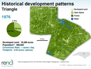
•In 1976, 1.9 percent of the Triangle qualified as developed land by RENCI’s definition.
•That grew to 3 percent in 1985, 5.6 percent in 1995 and 14.2 percent in 2005.
•The model predicts 36 percent of the Triangle will be covered impervious surfaces in 2040.
•The rate at which agricultural and natural land developed between 1976 and 2005 averaged 11 acres per day. The developed area grew from 18,286 acres to 136,682. FUTURES predicts development through 2040 will run at a rate of 17 acres per day.
•Between 1976 and 2005, the amount of developed land per person grew from .04 acres to .12 acres. FUTURES projects a “development footprint” of .15 acres per person by 2040, a 25 percent increase.
FUTURES combines those trends with anticipated population growth to project future development patterns.
John Hodges-Copple, the Regional Planning Director for the Triangle J Council of Governments — an organization of local governments including Raleigh and Wake County — said RENCI and Triangle J use the same population projections. So the study’s prediction of 2,298,086 people in the Triangle by 2040 isn’t new to him.
What will be new are the final report’s predictions of which areas will see the most growth. He said area planners will compare FUTURES’ projections to their own analyses.
“One of the key assumptions in the FUTURES project is that future trends will be a continuation of past trends,” Hodges-Copple said. “To take an analogy from the financial investment industry another group that depends on ‘informed speculation,’ past performance may not be an indicator of future results. So FUTURES gives us good information on what might happen if we keep doing what we’ve done in the past. But, of course, the future is never just like the past.”
Hodges-Copple said most communities in the Triangle J organization have plans to slow the development rate. Evidence indicates more households prefer to live in compact, walkable, mixed-use neighborhoods than live that way today.
Keough said that the relationship between population growth and development depends, among other things, on how the land is developed, for what purpose, and how intelligently it’s done. What looks like sprawl when vacant land first develops, he said, may become an urban setting down the road if it’s developed strategically.
Keough said Raleigh’s planning, which is heavily tied in with regional planning efforts, uses different models from RENCI to project future growth, but there’s “definite validity” to using satellite imagery.
He said he found the study interesting, and that local planners will take RENCI’s study into account as “our way of projecting growth is evolving and always has been.”
Gleave said that because FUTURES’ projections rely on a historical analysis that only runs through 2005, the effects of the recession may change the model’s projections. She said that RENCI will update calculations using 2010 development figures once it has the funding to do so.
Share your comments: What do you think about the Triangle’s growth and development?