The debut of the Rock ‘n’ Roll Raleigh Marathon and half marathon is Sunday.
The sold-out race benefits the V Foundation for Cancer Research and will have 12,500 runners from 49 states and five foreign countries. With more than 40 percent of race participants coming from outside the Raleigh-Durham area, the City expects the race to have a significant economic impact.
The race, which is this Sunday, Palm Sunday, has been a sore spot for area residents concerned about being able to get to church services on race day. City Councilors approved changes to the racecourse to lessen the blow, but concerns remain about traffic, road closures and noise.
The Rock ‘N’ Roll race series places live bands along the entire race route. Ted Metellus, course director with the Competitor Group, told City Councilors at their April 1 meeting that bands will start playing when the first runner arrives at that area — around 7:10 a.m. for the first band — and will continue playing until the last runner passes.
Metellus said notices about band locations have been distributed to the surrounding area. An effort was made to tailor the band to the area they will be playing. Bands with a slower, quieter music style will play in residential areas, while louder rock ‘n’ roll bands will be playing in non-residential areas.
Every live band location will have a stage manager on site to monitor the sound. Residents with complaints about sound are encouraged to contact the appropriate stage manager. Specific contact details are on the band location notices distributed to area residents.
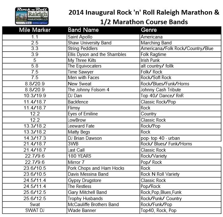
More information on race course bands and band locations.
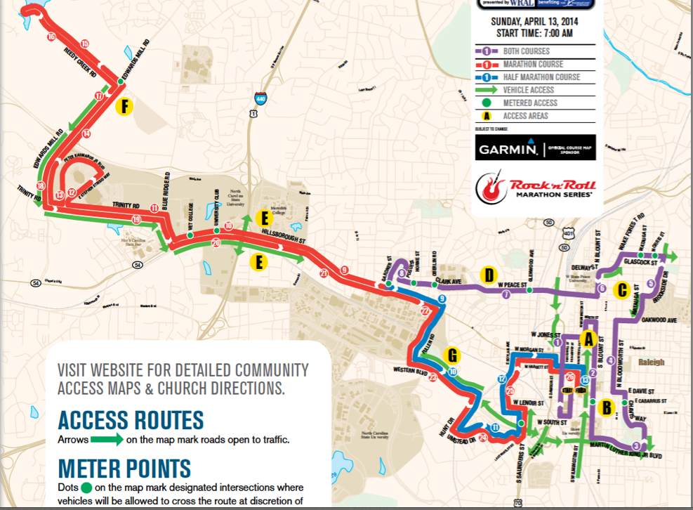
The race start time is 7:00 a.m., but most road closures will be in effect between 6 a.m. And 4 p.m. Streets will reopen on a rolling basis when the last participant passes and race materials are removed. Streets along the earlier portion of the course will reopen sooner than streets near the end of the route.

Race organizers have made an effort to reach out to local churches, area residents and members of the entire surrounding community to provide details about the race’s impact including fliers, email blasts and door hangers.
Fliers were made for each individual affected church that include information and directions on how to get in and around the course on race day.
Access directions and passes for affected churches.
Residents can download the following information on the Raleigh Rock ‘N’ Roll Marathon website:
Course Map
Road Closure Grid
No Parking Grid
Metering Locations
Race Information
Course Map with Alternate Routes
Alternate Access Notes for Course Map
Community Road Closure & Alternate Access Map – Downtown
Community Road Closure & Alternate Access Map – Hillsborough, Wade
Major road closures include:
S. Salisbury from W. Davie Street to W. Cabarrus Street (closed 4/12 – 4/13)
Fayetteville Street from W. Hargett Street to E. Lenoir Street (closed 4/12-4/13)
S. Salisbury Street from South Street to W. Hargett Street
S. McDowell Street from W. South Street to W. Jones Street
N. Blount Street from E. North Street to MLK Boulevard and from Delway Street to E. Peace Street
MLK Boulevard westbound from Blount Street to Chavis Way
Chavis Way from MLK Boulevard to E. Davie Street
* Southbound lanes open to traffic from southern Noble Oak Way to MLK for Chavis Heights
W. Morgan Street from S. Boylan Avenue to S. Dawson Street
W. Hargett Street from S. Dawson Street to Fayetteville Street
W. Jones Street from N. McDowell Street to N. Wilmington Street
Bloodworth Street from E. Davie Street to Oakwood Avenue
Brookside Drive from Watuaga Street to Glascock Street
Glascock Street from Brookside Drive to Wake Forest Road
Wake Forest Road from Glascock Street to Mordecai Drive
* Northbound lanes open from Person to Sasser
E./W. Peace Street westbound from N. Blount Street to W. Johnson/Bellwood Drive
Clark Avenue westbound from W. Johnson Street/Bellwood Drive to Gardner Street
Hillsborough Street whole road closed from Gorman Street to Pullen Road; westbound only closed from Gorman Street to Blue Ridge Road
Blue Ridge Road northbound from Hillsborough Street to Trinity Road
Trinity Road westbound from Blue Ridge Road to Edwards Mill Road
Edwards Mill Road northbound from Trinity Road to Reedy Creek Road
Reedy Creek Road from Edwards Mill Road to Edwards Mill Road
Pullen Road from Hillsborough Street to Western Boulevard
Western Boulevard eastbound from Pullen Road to Hunt Drive
W. Lenoir Street from S. Saunders Street to S. Boylan Street
S. Saunders Street southbound from Lake Wheeler Road to Lenoir Street
*Northbound lanes open to traffic from Jamaica Drive to W. South Street for Gateway Park residents
S. Boylan Avenue from W. Lenoir Street to W. Morgan Street
Major roads open on race day:
Capital Boulevard
Eastbound Clark Avenue/Peace Street from Horne Street to N. Blount Street
Eastbound Hillsborough Street from Blue Ridge Road to Gorman Street
Westbound Western Boulevard; eastbound Western Boulevard between Hunt Drive and MLK Boulevard
Eastbound Martin Luther King Boulevard
Southbound Blue Ridge Road
Eastbound Trinity Road
Southbound Edwards Mill Road
Residents can complete a community contact form for assistance with questions that are not answered on the website or if additional help is needed with alternate directions.