When Nicholas Sailer moved from New York City to Raleigh in 2014, one of the things he knew he’d miss was the iconic NYC Subway System map
“Anyone who’s been to New York for any period of time, whether you’ve just visited for a few days or lived there for 10 years, everyone recognizes that iconic map of New York,” Sailer said in a promotional video for his just-released Raleigh City Subway Map.
Editor’s note: Although The Record had discussed a potential giveaway contest with Sailer earlier this week, we were unable to reach him in time for publication of this article.
On the map’s website, Sailer said his next thought was, “I wish there was a map of Raleigh that everyone knew, recognized, and referred to. Even if it’s fictional.”
“I started designing a rough draft of a map of Raleigh, as if Raleigh had a subway system similar to NYC,” Sailer wrote.
“My idea for this map is that it would make me feel like I’m in a big city, where lots of things are happening at each stop, and there are reasons to go to each station and explore,” he added.
In April of 2015, about a year after Sailer moved to Raleigh, longtime Raleigh resident Matt Lail was on vacation with his wife and children in Paris.
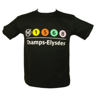
A T-Shirt promoting the Paris Metro
“We were waiting in line for, you know, Notre Dame or something and I saw a little souvenir shop across the way; I walked in and noticed they were selling T-shirts of the Paris Metro Map,” Lail said in an interview with the Record earlier this week.
“I thought, that’s kind of a cool thing, it’d be nice if Raleigh had a Metro, that’s something I’ve been interested in for a long time, I think it’s a cool, progressive, forward-thinking thing for us to have.”
“I’m not even sure we’re a good fit for it, it’s sort of a pipe-dream kind of thing,” Lail said.
Different Approaches, Similar Goals
Sailer spent a few years outlining and perfecting his map, modeling it in some ways, he wrote, after the NYC Subway System version he was homesick for.
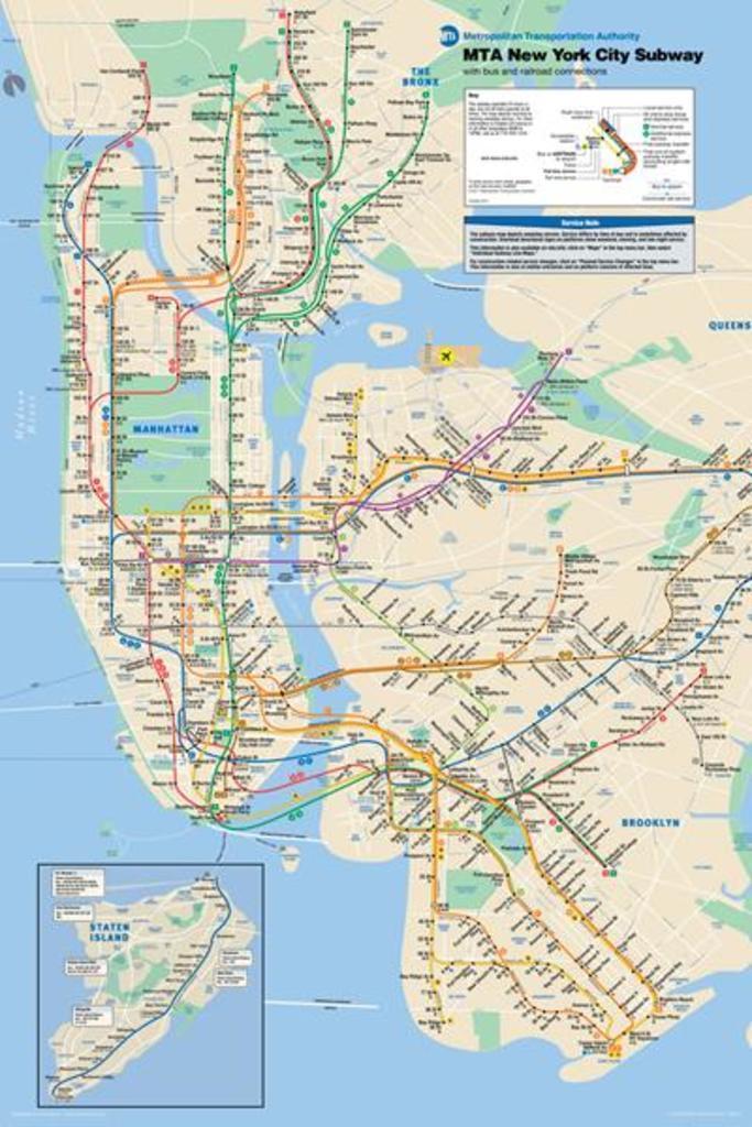
A map of the NYC Metro System
Lail described a more haphazard approach.
“I kind of sketched out where I thought the key transit stops would be, where the metro stops would be,” he said.
“And when I say sketch them out, I mean I literally printed out a Google Map of Raleigh and took a pen and made little stars and dots on the map and said, ‘This would be a good spot, this seems like it would make sense.'”
Lail collaborated on the project with Jedidiah Gant, co-founder of the popular NewRaleigh website turned social media outlet and who now works as a media strategist for Myriad Media. Lail works as an account supervisor at G & S Business Communications.
“As [Jedidiah] and I were talking about where the stops would be, our conversation sort of expanded into, you know, what would that mean to the neighborhoods from an identity standpoint?” Lail said.
“Would it be something that would evolve into people wearing shirts and hats that have their Metro stops listed on it? Would people identify their neighborhood, where their house is, based on Metro Stops?”
“All these things happen in bigger cities,” Lail said.
On his site, Sailer wrote that his hope for the map was that:
“Venues, restaurants, offices, and co-working spaces across Raleigh will display this map and that it will serve as a visual and geographic reference guide to the people of Raleigh.”
“I hope people will joke that they live close to the Trailwood stop on the ‘A’ line, or that they’re taking the ‘N’ line to Atlantic Ave. This kind of geographic awareness serves a community by bringing people together around a common understanding of geography and culture,” Sailer wrote.
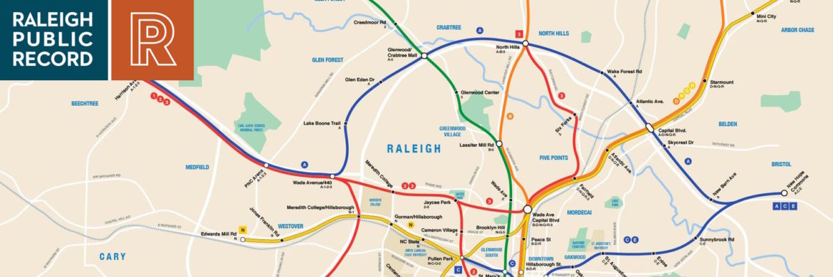
Raleigh City Subway
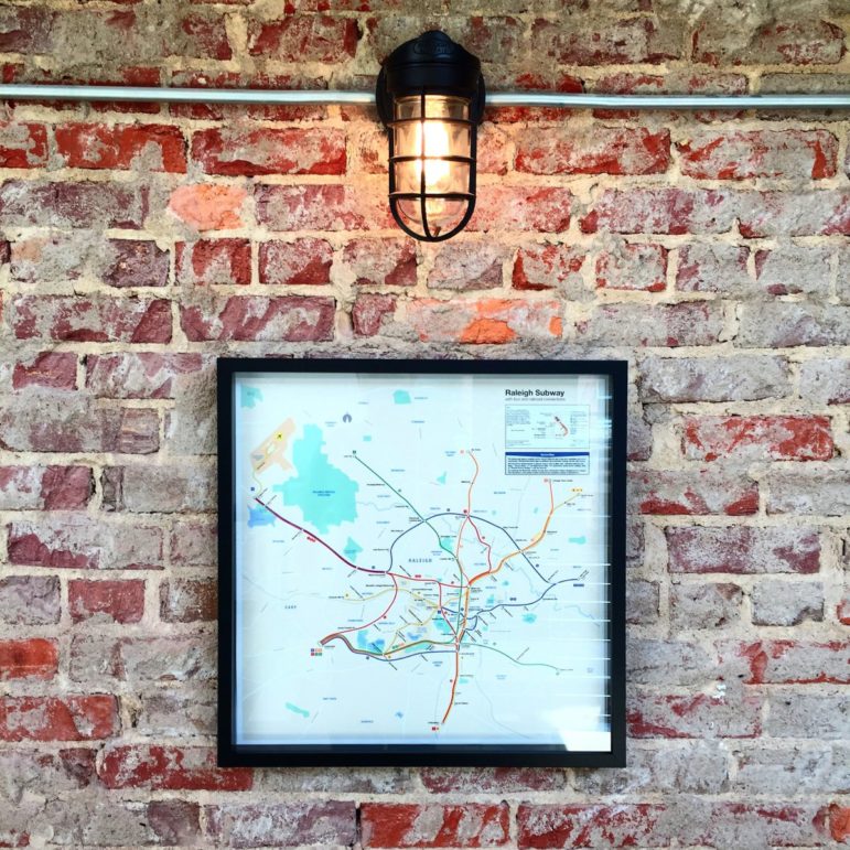
A framed version of the map
Lail agreed.
“As you’re thinking about where these fictional, potential Metro Stops would be, what they would be named and who they would be named for, it sort of lends itself to a sense of celebrating history and milestones and famous people and innovators and that sort of thing.”
In addition to contributing to a sense of community in Raleigh, Sailer wrote that he hoped his map would “spark public interest and awareness” for public transit systems in Raleigh. This would be something, he wrote, that “Raleigh could deeply benefit from as it grows and changes in the future, and over the next 5 years.”
Once again, Lail was on the same page.
“Very similar to the idea behind the map that’s out there,” he said, “was the idea of promoting transit, and this idea of, what would it be like if you have a Metro system in Raleigh?”
One Big Difference
Aside from the fact that Lail had been inspired by the Paris Metro and Sailer the NYC Metro, the biggest difference between the two projects is, of course, the fact that Sailer’s is now on sale to the general public for $30 a print.
While Lail and Gant went so far as to compile a lengthy spreadsheet full of potential stop names and locations, which included, among others, Moore Square, potentially named “Big Oak” and Five Points, potentially named “Hayes Barton,” Lail said he never managed to find the time to put together a complete map.
“I had other projects called my children that got most of my time,” he joked.
He said he was excited when he first saw the announcement for Sailer’s map; “It meant I wasn’t insane!”
“I think it’s a very cool thing that [Sailer] developed that poster; our company just moved into a new office and I might have to see if we can get one for our office,” Lail said.
“It’s a very cool concept and I’m glad he was able to take that logical next step and really map out what that might look like, I think it’s cool.”
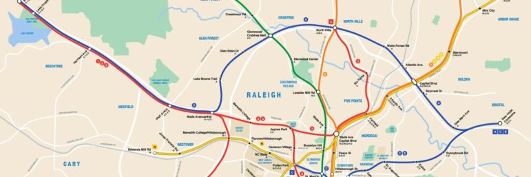
Raleigh City Subway
The Raleigh City Subway Map
In his promotional video, Sailer said he hoped people would now “have a reason to put a map of Raleigh on their wall.”
“They’ll start to feel more proud and connected to the geography of their city; when people start to see this map in restaurants or bars or offices across the city, they’ll start to have a shared vision of the city they live in, a shared vision of what the city can become.”
Thanks to a grant from The Awesome Foundation, Sailer was able to distribute 30 maps for free — full disclosure, The Record requested one — although we do not know at this point if any remain.
One final note: although the Raleigh Subway map is certainly unique, we’d be remiss if we didn’t point out another locally-focused map, which recently came to our attention, this one of Raleigh’s ITB neighborhoods and produced by mapmaking company Blue is The Land.
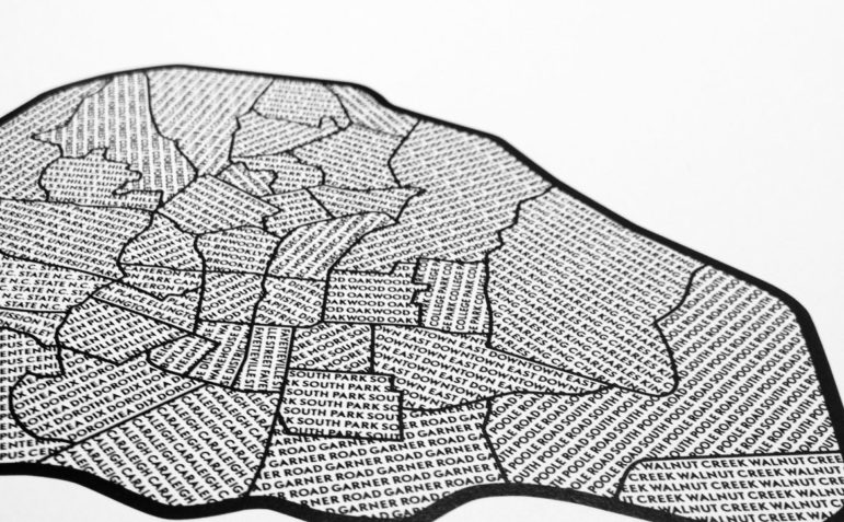
Blue is the Land
This map of ITB Raleigh has the names of each neighborhood displayed throughout