About one-third of Raleigh’s land is about to be rezoned.
The rezoning is the second phase of implementing the city’s new zoning code, the Unified Development Ordinance. The UDO went into effect on Sept. 1 after nearly three years of development and review. While the UDO is officially on the books, the city must continue to use the old code until the mapping phase is complete.
“Staff is in the midst of drafting a major revision to the zoning map to retire all of the old zoning districts … and replace them with UDO districts, which is a pretty mammoth undertaking,” said Deputy Planning Director Ken Bowers during Tuesday’s Planning Commission meeting.
These old zoning districts are called legacy districts. Bowers said legacy districts are any zoning districts that appear in the old development code but do not appear in the UDO.
“The remapping is the process of retiring all of the legacy districts off the map and replacing them with the closest equivalent UDO district that matches up with the existing zoning, existing use, and the city’s land use policies,” Bowers said.
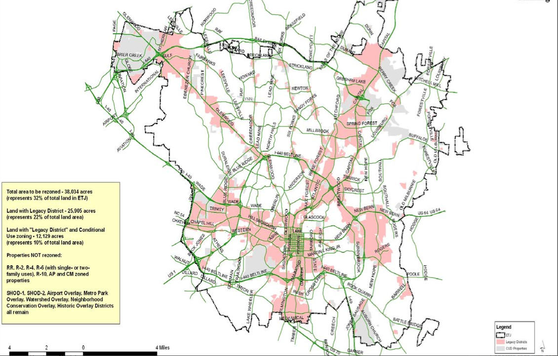
According to Bowers, about one-third of the city’s land area will be remapped in some way, but it will primarily affect income-producing property, commercial and multi-family property. Most residential property will not be affected.
“What we’re trying to do is implement the UDO throughout the city,” Deputy City Attorney Ira Botvinick said. “We’re trying to maintain the status quo as best we can but apply the UDO zoning districts.”
City planning staff has been working on the map for more than a year. Once the draft is complete, it will be available for public review. From there the new zoning map will go to the Planning Commission to review before an official public hearing is set. The City Council table will be the last stop.
While he was hesitant to give any specific dates or guarantee a specific time frame, Bowers expects the initial draft of the new zoning map to be complete this spring.

Image provided by City of Raleigh
A map showing the areas that will be changed for the UDO, with legacy districts shown in pink.
The public will have about four to six months to review the draft map before the Planning Commission begins its review.
The public can offer comments during all four stages of review via email, phone and mail as well as a special website that will be setup for the process. Planning staff will be doing presentations at Citizen Advisory Councils and some homeowners association meetings.
Residents within a 100-foot radius of an affected property will be notified by mail about the rezoning.
Commissioner Adam Terando questioned the 100-foot radius.
“The 100-feet radius seems a little stingy to me as far as the notice given to the surrounding neighborhoods,” Terando said.
Bowers said that staff can consider extending the radius so that more people are notified but added that the related two scheduled mailings will already cost about $30,000.
Bland Road Property Rezoning Approved
Commissioners Tuesday approved a request to rezone a 0.8-acre piece of land on Bland Road just east of its intersection with Wake Forest Road.
The property owners plan to sell the property and realized they would make more of a profit by selling it for commercial use instead of residential because of the property’s location.
The case was sent to the Committee of the Whole in October to allow more discussion on the proposed rezoning, and to give the applicant time to reach out to nearby property owners about rezoning several of the properties at one time.
Commissioner Isabel Mattox said although the proposed rezoning is inconsistent with the Future Land Use Map and the Comprehensive Plan, it is consistent with the character of the surrounding area.
“It is reasonable and in the public interest because there is a good bit of office in the area,” she said.
Commissioner Eric Braun echoed her sentiment.
“If the property develops as office it would complement the other retail and office development that is in the area as well,” he said.
Ray Road Rezoning Extended 45 Days
A decision on controversial plans to rezone land in the Falls Lake Watershed has been delayed. The 17.5-acre property is located on Ray Road, north of Strickland Road.
Commissioner Quince Fleming said the 45-day extension will give staff more time to review the information provided by the applicant.
Jarrod Edens, of Edens Land Corporation, requested the rezoning to construct a higher-density housing development on the property. He said the proposed development will be constructed as a conservation development, which requires 40 percent open space, and density will be added by putting smaller houses with shorter driveways on smaller lots.
Area residents and commissioners, however, voiced concerns about the impact the rezoning would have on water quality and the surrounding area.