Category: Transportation / Parking (Page 7 of 10)

One Small Step for a Vital Greenway Connection — One Wrong Step for the Environment? So Argue Property Owners.

There’s a lot at stake… First consider Sig Hutchinson’s dream for area walkers, runners and bikers:

Sig Hutchinson, co-founder of the Raleigh Downtowner has long been working to build 150 miles of greenway trails spanning Falls Lake to Durham’s American Tobacco complex, and he sites Crabtree Creek as the connection point for the rest of the grid.  Sig says, “The (1.3 mile) Crabtree Creek Greenway connection to Umstead State Park is the final link in a hundred plus mile greenway system”.

The DLA also sees an advantage in this connection, since it allows downtown residents to not only walk, run or bike on greenways from Downtown to Umstead Park, but they’ll be able to continue through the park and connect through the new Crabtree Creek greenway onto Shelley Lake, or east past Raleigh Boulevard and all the way to New Bern Avenue.  With plans for a future 3-mile link to Downtown from Raleigh Boulevard, residents will enjoy a continuous 26 mile loop.

So what is the problem?

This connection has been shown on greenway maps for years, but the city needs land for the easement, which runs through Hanson’s quarry.  Now that the quarry seeks to expand, owners have proposed a trade.  If the city allows them their request for expansion, then they agree to unlock this important greenway connection.
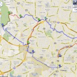
Downtown GreenwayMapsClick the image to enlarge 

This image shows how the future 1.3 mile Crabtree Creek greenway section would connect to the existing greenways through Umstead Park.

Consider the issues involved:A website blockthequarry.org promotes community opposition to the quarry expansion, and a recent article from the N&O, Raleigh quarry wants to grow, also outlines concerns.


A mining company wants to extend an 80-year-old rock quarry that abuts an upscale neighborhood and Umstead State Park.  But a group of North Raleigh residents is fighting the expansion, saying it could lead to environmental damage, noisy neighborhoods and diminished property values.”  

Indyweek.com also talks about the issues involved – Raleigh quarry quandry, creek or greenway?.    


Sig Hutchinson continues to fight for walkers and bikers through his Greenway ACTION Alert, asking residents to send a message to Raleigh City Council members regarding this “last piece in the Greenway System yet to be secured and the gateway connecting Raleigh to the rest of the region.”  Sig says, “When I talk to groups interested in greenways, far and away the most important segue that people talk about is this connection at Crabtree Creek.  And now the option for the quarry to expand creates a window of opportunity for the greenway.  If this goes away, it’s just too easy for them to walk away and never open the door again.”


The Planning Commission Committee of the Whole is expected to decide on the issue at their scheduled meeting on Tuesday, February 1st (9-11am) at the Raleigh Municipal Building, Rm 303.  The meeting is open to the public.

Where do you stand?

Come to the meeting so you can make your voice heard in this important decision for Raleigh’s development.

Mastering the Plan for Moore Square Bus Station

If you’ve waited at the R Line stop by Moore Square Bus Station, you’ve probably noticed what the architect, Roberta Fox is addressing in her preliminary studies for revamping the area.  Hired by the city to spur a master redevelopment plan in the 1st quarter of 2011, Roberta has built a model of the station and surrounding area.  Using the model, which includes interlocking pieces that can be moved around, Roberta showed me some of her ideas that would improve capacity for handling more bus traffic and parking within the facility.   

My query started with David Eatman, City of Raleigh Transit Administrator.  David explained that the Moore Square Station did indeed present some challenges for the city.  CAT buses idle on Wilmington and Blount Streets, queuing there because there aren’t enough parking spaces within the facility.  Looking out ten years, David says that 40-80 more buses will be required to handle the projected increase in population. Even with the plans for Union Station, Moore Square would become a secondary hub for routing bus traffic.


What are the solutions?

I asked about what can be done so people walking through or waiting at the station can feel more safe and comfortable.

David responded that more “feet on the street” were needed to enforce the existing loitering ordinance, and noted that security was enhanced this past August with the addition of two full-time officers (with arresting authority) dedicated to the station area.  

Roberta explained that security can be also be improved through the facility design based on the following concepts.  

  • Create an environment that is friendly to pedestrians walking through the area.
  • Fill the space with people who are there for a purpose.
  • Open up the opportunity for neighboring business to encroach upon the space.

Roberta says you need to “activate the empty spaces and take away the eddies or nooks and crannies where people can hang out without being seen.  Adding people with a purpose allows for self-policing”.  

The first example of a business taking advantage of the station’s adjoining area could come in the form of a rumored coffee shop that may offer outside seating overlooking the inner courtyard Transit Mall off Wilmington Street. 

David Eatman and Roberta MK FoxIt’s expected that the city will organize a public participation event, similar to the ongoing Moore Square redesign process, but without the contest.  David says that the public input is very important and that the city will be open to creative ideas on how to best use the space.

The construction that you see along Blount Street today is a small project (to be completed next month) to remove the fountains and add better lighting, as well as an additional walkway and seating.  


But there is a lot more coming . . . so stay tuned.  Think about what you’d like to add to this important project for re-envisioning our city.  I’m thinking about a mix of retail floors within the parking deck.  Tell us your ideas. 


Getting Around Downtown: This holiday season, enjoy the many different rides offered in Downtown Raleigh.

If you live in downtown Raleigh, you’re already sold on the ease and excitement of urban dwelling.  If you’re living in the ‘burbs, chances are you venture in to take advantage of the delicious dining, entertainment, shopping and family activities that fill the downtown scene.  

This article featured in Midtown MagazineAnd if you’re a daily commuter, you’ve probably figured out your favorite place to get coffee or pick up flowers for your lovely wife before you head for home. 

Regardless of where you rest your head, this holiday season you’ll find it easier than ever to get around downtown.  The old reliables continue to make navigating the city a breeze and a new addition makes heading out of town as simple as swiping a card.  And an added benefit?  All the transportation options we’ve highlighted are green, helping to make downtown Raleigh a more environmentally friendly city.

Here’s what you need to know:


WeCar

WeCar, a division of Enterprise, is the newest method of transportation to hit downtown. This not-your-traditional-rental-car service provides downtown Raleigh residents with access to fuel-efficient rental cars that are available for a minimum of one hour or a maximum of 24 hours for a low hourly rate.  This car-sharing community is especially enticing to those who need a car to scoot around town for some holiday errands or take an afternoon outing to visit friends.

Getting your car couldn’t be simpler.  Just visit the WeCar website and request to join the downtown Raleigh car-sharing community. After your request is processed, stop by the local Enterprise office, where they’ll take a peek at your valid driver’s license and in exchange, give you your membership card.  You’re ready to rent. 

When the need for the car arises, log on and reserve your vehicle.  You’ll be directed to the location of your car, currently either West at North Condos on Harrington Street (conveniently, an R-Line stop) or at the Enterprise office on McDowell, where the swipe of your card will grant access to your vehicle.  Once your rental period is over, return the car to its original spot. 

“WeCar is ideally structured for city living, offering accessibility without commitment. This in turn helps the city, by reducing the amount of cars on the road, fuel consumption, air quality and the number of parking spaces required,” says Adam Schneider, Regional Vice President for Enterprise.

Triangle Segway

Experience Raleigh from a slightly different angle by taking advantage of a tour offered by Triangle Segway. Whether it’s your holiday houseguests, an event for your business, or you and your family wanting to get out and explore Raleigh, a Triangle Segway tour is the ideal way to spend a couple of hours.  After a brief training session, where you’ll be provided with helmets and a wireless audio pack so you can hear your guide’s narration, you’ll be ready to glide across the city.  Tour options include an Experience Tour, with sights such as the NC State Capital, Governor’s Mansion and City Market, a Raleigh’s Great Romance Tour, including Oakwood Cemetery, and NC State. 

Raleigh Rickshaw

Since 2007, Raleigh Rickshaw has provided a unique and eco friendly form of free transportation for diners, bar hoppers, newlyweds, families and tourists across downtown Raleigh through the use of pedal cabs.  “As a matter of fact, last year Raleigh Rickshaw had over 80,500 riders and drivers peddled over 15,000 hours,” says owner Donald Mertrud.  An amazing achievement, but one that will be bypassed by the time you’ve read this sentence. 

With over 20 Raleigh Rickshaws traveling between the five downtown districts, getting from point A to point B is both fast and smooth.  While you always have the option of flagging down an empty rickshaw to take you from the restaurant to the show or from the museum to the art gallery, Raleigh Rickshaw does have a dispatch service available by telephone or easily accessible on-line, so it’s easy to make a reservation.  And who doesn’t love the invigorating, fresh air of a cool night under city lights as you take in the downtown landscape?  It’s the ideal mode for getting around when it’s too close to hop in the car and just little too far for a walk. 

If Mertrud has his way, soon, Raleigh Rickshaw drivers won’t be the only ones pedaling around downtown Raleigh.  Raleigh Rickshaw is working in conjunction with the City of Raleigh to launch a public use bicycle program.  Stayed tune for more information.

R- Line

Yet another environmentally friendly approach to urban transportation, the R-Line is about to celebrate its second anniversary.  This free circulator service, which means that it “circulates” around a defined community instead of traveling far distances, features hybrid electric buses that will connect you to restaurants, retail, entertainment venues, museums, hotels and parking facilities in downtown Raleigh. 

Two green and blue buses run every 10-15 minutes, with a route that circles from the Convention Center to Seaboard Station and Glenwood South during the day, then expands to include the Warehouse District and City Market in the evening, making the R-Line an uncomplicated, convenient and enjoyable way to run errands during lunch, be transported to your favorite shop, connect with friends for drinks or just get a ride home.     You’ll know you’ve found an R-Line stop, for the signs sport the big “R” logo.

J&L Carriage

For over ten years, J&L Carriage has been offering rides to downtown residents and visitors.  You’ll find the carriages in the mall between the museums the first Friday, Saturday and Sunday of the month, where you can just walk up and hop on, enjoying a family ride or a narrated tour of the city.  Rides are also available for your more romantic occasions, weddings, festivals, parties and even funerals by appointment.  And for those of you with younger children, be sure and ask about Marbles, J&L’s miniature horse, who pulls a miniature carriage.


This article was written by Ilyse Lane for the Midtown Magazine, and was featured in their November / December edition.  The Midtown Magazine is now online!  Visit them at www.midtownmag.com.


Re-Imagining Capital Boulevard

Picture this.  It’s a rainy, dark evening and our family has driven two cars all the way from Lancaster, Pennsylvania to Raleigh, our new home.  I advise our son in the front car to stay in the right lane as we drive south on Capital Boulevard into the city, since we don’t know the lay of the land.  It isn’t long before we’re confused.  With every mile, our lane disappears and we’re forced to the left.  This is the strangest traffic pattern we’ve encountered in a long time, and we ask ourselves, This is where we’re going to be living now?

Capital Boulevard has presented an array of problems that have challenged planners over time, and last week, another – hopefully final study was initiated to brainstorm about possible alternatives to recreate the entry into Raleigh from the north.

The Capital Boulevard Corridor Study’s Public Design Workshop was held this past Saturday and I attended the morning session, where the 75 or so in attendance broke into small groups, each focusing on one of four topics:

  1. Land uses and economic development
  2. Urban design
  3. Transportation
  4. Ecology

Click to enlarge

Here is a map of the area included in the study.  It includes the north-south section of the road from the Belt Line to Peace Street, as well as the area that runs east-west between the rail corridors. 

Anyone who has ever driven down Capital Boulevard understands the need for major improvements.  And the city recognizes the need to improve safety along the corridor, replace the worn-out bridges and interchanges, and to do something about the ongoing flooding and water quality concerns.  


Key themes arise in any discussion of this heavily traveled area.

One goal is to create new vehicle connections into and across the corridor. 

The rail lines that form the east-west boundaries of the study area are clearly major obstacles to vehicle connectivity.  Though trains were an important part of the corridor when it was mainly industrial, today heavy industry has all but disappeared, and the rail lines effectively block the adjacent neighbors from getting into and across the corridor.

Solutions discussed

  • Redesign the boulevard into one-way paired streets with separate frontage roads that would handle new intersecting streets to / from surrounding neighborhoods.
  • The rail corridor on the east side of Capital Boulevard has been designated to support passenger (light) rail.  Find a way to consolidate or reconfigure this corridor for continued freight operations, such that the existing freight rail corridor on the west side of Capital Boulevard could be relocated to a less densely populated area.

Another goal: slow down the traffic!

Given that there are presently few other options for vehicles traveling from the north to Wade Avenue / I-40, and into Downtown, Capital Boulevard handles an unavoidably large volume of traffic.  The high volume of traffic and lack of east-west connectivity has stunted significant mixed use development despite general proximity to North Raleigh’s office parks and the Downtown government and commercial area.  Traffic congestion is already a problem, and the projections are for traffic to increase by 40-70% over the next 25 years.  

Solutions discussed

  • Plan for handling an increasing volume of traffic with new options for vehicles to get into the Downtown other than on Capital Boulevard.  Examples include new connections to Blount Street on the east side, and on the opposite side, extending West Street to meet Wade Avenue (at grade), and then onto Fairview Road.
  • Slow the traffic and narrow the street at the southern end of the corridor, between Wade Avenue and Peace Street – the boulevard becomes a parkway.
  • Create new “roundabouts” at the corridor’s intersections with and along Peace Street.

Next: bring back Devereaux Meadows

The scale of this project offers a unique opportunity for the city to create needed green space while addressing the water pollution of Pigeon House BranchDevereaux Meadows, site of a former minor league ballpark was once an important entertainment area for Raleigh residents, though today it’s covered up by under-used industrial and distribution buildings that sit along the corridor.

Solutions discussed

  • Open up Pigeon House Creek and create a stream with associated green space for residents.
  • Turn Devereaux Meadows into a park, and create new access points for pedestrians via a bridge from Seaboard Station / Peace College.

And also: Create a multi-modal corridor (cars / trains / buses / bicycles)

The South Eastern High Speed Rail (SEHSR) corridor will route through either the east or west side of Capital Boulevard, and the rail corridor on the east side of Capital Boulevard has been designated to also support passenger (light) rail.  By next year the specific routes will be determined, along with station locations and associated bus connections.  The corridor also includes an east-west greenway along Crabtree Creek that offers the opportunity for new pedestrian and bicycle connections.

Solutions discussed

  • Design the vehicle, pedestrian and bicycle connections to fit with the new train and bus stations once they are defined next year.
  • Connect the Crabtree Creek Greenway and the Downtown with a new 3-mile greenway that would also cross the corridor over a new pedestrian bridge between Devereaux Meadows and Seaboard Station.  See map for a possible route.

This is an especially opportune time to finally address the concerns raised by past studies and echoed again in this latest public design meeting.  Raleigh is positioned well for significant growth and it’s critical that we all support plans that re-vitalize the northern gateway into Downtown Raleigh by integrating Capital Boulevard with the coming passenger rail and opening up new development opportunities, while promoting sustainable land use practices.  


I invite others, especially those who attended the workshop to add their comments.


Don’t Let the Train Pass You By: Public Workshop Coming Up, and This Time It’s Not About High-Speed Rail

Join me in the vision: commuter rail carrying workers from Downtown Raleigh to RTP and government workers from their homes in Cary/Apex to Downtown Raleigh; and light rail taking shoppers from Downtown Raleigh to Triangle Town Center, and transporting visitors from Cary/Apex to Downtown Raleigh.

With all the press lately about high-speed rail, it’s easy to get confused about the various transit initiatives.  (See Buses,Trains and Automobiles.. All Aboard Raleigh’s Public Transport Network for a review of the different transport initiatives underway in Raleigh.)

There’s a  Public Workshop coming up on Tuesday, but no talk about high-speed rail pathways here.  Instead, this workshop will be about the Triangle Regional Transit Program (TRTP) that focuses on the vision for enhanced bus services (in separate, dedicated lanes), commuter rail corridors (on existing freight tracks), and light rail (on new tracks) that will serve residents in Wake, Durham and Orange Counties.  Click here for more information on the various types of transit technologies.

The Downtown Raleigh workshop will be held on Tuesday (September 14th, from 4:00-7:00pm at the Chavis Community Center, 505 Martin Luther King Jr. Blvd, Raleigh (map).

Why so much discussion about new mass transit options?

With all the transit projects  designed to support our area’s growth, there is a critical need to coordinate these efforts. .  Commuter and light rail will share some portion of the rail corridor with the Southeast High Speed Rail Project and this is also where Union Station plays an important role as a multi-modal center for bringing together all forms of public transportation.

Click to enlargeThe TRTP study views the area as three corridors: 

1. Wake County Corridor

2. Durham/Orange County Corridor

3. Durham/Wake County Corridor


Wake County Corridor

Click to enlarge

The Wake County Corridor begins in the vicinity of the Triangle Metro Center in Research Triangle Park (RTP) and follows the existing North Carolina Railroad (NCRR) corridor to Downtown Raleigh where it turns northward, continuing on the CSX corridor to near Triangle Town Center.

The Wake County Corridor could also include future extensions from Triangle Town Center to Wake Forest and from Downtown Cary to Apex.


Durham/Orange County Corridor

Click to enlargeThe Durham/Orange County Corridor begins in Chapel Hill in the vicinity of the University of North Carolina Campus and roughly follows the US 15/501 corridor north to the City of Durham, where it turns eastward to follow the existing NCRR corridor to approximately the Triangle Metro Center in RTP.


Durham/Wake County Corridor

Click to enlargeThe Durham/Wake County Corridor would involve a study of transit corridor options that follow the existing NCRR corridor from Durham through RTP and Downtown Raleigh toward the Wake-Johnston County line.

There are lots of decisions to be made, including transit modes, routes and station locations.  All our critically important.  So become educated about the various options by attending workshops like the one coming up on Tuesday.

Your input can make a real difference, and help shape our city for years to come.  I look forward to seeing you there!

« Older posts Newer posts »