At 444 pages, the North Carolina Oil and Gas Study is an extensive document. During the month of April, Laura White will be tackling this entire document, conducting interviews with experts and breaking it down section by section so you can be as informed as possible.
The Record’s goal here is not to tell you what to think about fracking, but to arm you with the information you need to make an informed decision.
Check in a few times a week, and watch for #NCFrackFocus on Twitter for daily updates as we work our way through what you need to know. Have a specific question you want us to address? Email lwhite@raleighpublicrecord.org or Tweet @lewhite.
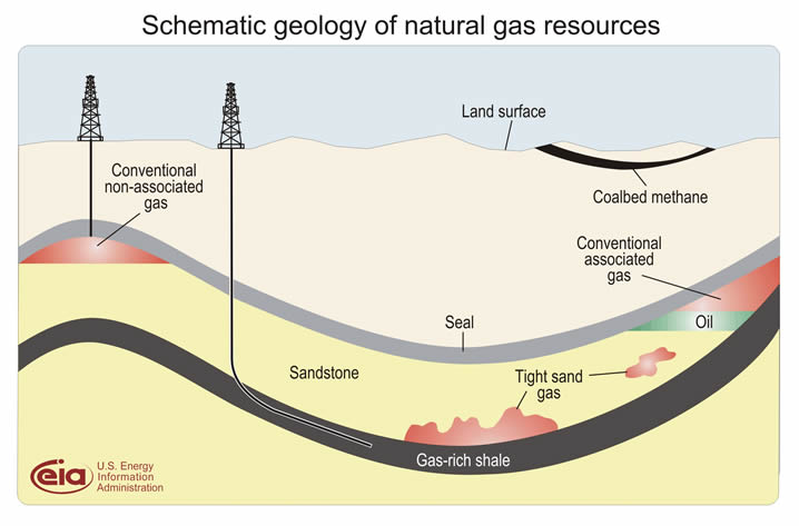
The U.S. Geological survey has two categories of oil and gas resources: conventional and unconventional, otherwise known as continuous. Conventional resources have been the industry’s source of oil and gas for more than 200 years, and these resources are made up of three parts: the source rock, the reservoir rock and the cap rock.
In the conventional system, oil and gas migrate from the source rock into the reservoir rock, where they are trapped by the cap rock until they are tapped. This system does not apply to North Carolina, however, because shale gas is generally extracted as an unconventional resource.
So we’ll talk about that system instead.
Unconventional or continuous oil and gas resources are different from conventional sources because there are only two parts: source/reservoir rock and cap rock. This means these resources are extracted directly from the source rock.

According to the report, geologists have been learning about the organic-rich shale rock of the United States for more than 100 years. It states that there are 27 shale gas basins that have been identified around the US, and that they vary in age from Devonian to Mississippian to Jurassic — which spans more than 230 million years.

This section goes on to talk about how to determine the depth of these shale rock basins.
One way is by using a portable gravity meter, gravimeter, or gravometer, as it is spelled in the report. This is an instrument that can measure the pull of gravity to map the edge of basins and show where the basin is deepest by measuring the magnetic characteristics of the original rocks and the sediment that filled the basin.
This is what it looks like:

Image Courtsey of National Geodetic Survey Geosciences Research Division
Another method is seismic reflection, where vibrations or sound waves are sent into the earth and recorded when they reflect off the rock layers thousands of feet below. This profile, once processed, illustrates a vertical slice of earth that is not measured in feet but in the amount of time it took to generate the sound waves. This is what that process looks like:

This was one of the ways it was determined that the depth of the Sanford sub-basin was 7,000 feet. Here’s one of these seismic lines from that particular location:

The report then goes on to discuss why geochemical analyses of this shale rock is necessary in answering three questions related to natural gas production. These questions are: is there enough organic material in the rock to generate oil or gas, what is the type and maturity of the kerogen (which decides whether the rock produces methane, oil or gas), and the third question is … what? The draft never explicitly states the third question. Whoops.
Finally, after an extensive science lesson in what hydrocarbons are, and why they are important, subgroup C of this section begins to address the methods of actually extracting them, breaking this process down into eight steps: mineral leasing, permit acquisition, road and pad construction, drilling and completion, hydraulic fracturing, production, workovers, and plugging and abandonment/reclamation.
And suddenly, this section goes from all sorts of scientific absolutes to a whole lot of — once again — uncertainty. Read about the rest of this section tomorrow.
Confused about some terms? Check out our glossary of fracking words.