Category: Parks & Green Space (Page 4 of 6)

New Greenway Connections Multiply Options for Biking, Running and Walking in Downtown Raleigh

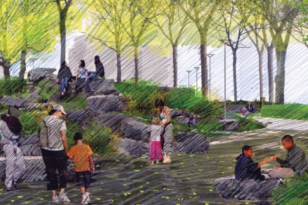
Have you ever noticed anyone in a bad mood on the Greenway?  Neither have I.  It’s just miles of smiles!  So I’m always excited when I hear of plans to increase those miles…

This week, I attended the lunch time forum at the Urban Design Center to get an update on the latest plans for Raleigh’s greenway grid.  As a Downtown resident, I’m particularly interested in any new routes that make it possible for me to enjoy the Greenways without having to get in my car first.

Until Now

As background to those new to the Greenway, I posted a Greenway Guide a year ago that included a detailed map of the only Greenway connection into Downtown Raleigh from the south, which links up with the Walnut Creek and Rocky Branch Greenways.

More recently, I talked about a vital connection to Umstead State Park, where issues with neighbors and an adjacent quarry were holding up a necessary right of way for the 1.3 mile link to the Crabtree Creek Greenway.  Sig Hutchinson (Mr. Greenway) has been working on this issue for the city, and it appears a solution has been reached.

Now Two New Connections

This week I learned some other exciting news about two new Greenway connections into Downtown Raleigh.

First, a more convenient connection into Downtown from the west will start at the Convention Center, travel along Cabarrus Street through Boylan Heights (along sidewalks), and link up with the Rocky Branch Greenway near the Central Prison along Western Boulevard.

Second, a connection going north from downtown will link up with the Crabtree Creek  Greenway from Raleigh Boulevard.  This one has been talked about for a while, but I’m hearing that the route has now been worked out.
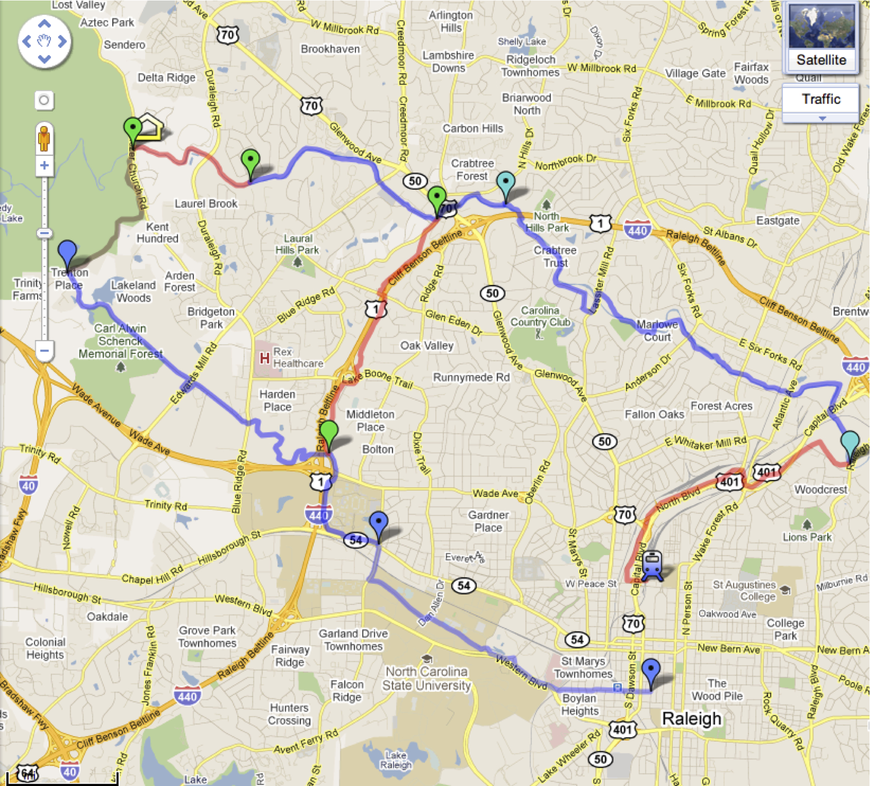
Click to enlargeHere is a map showing where all the new greenways extensions will connect into Downtown Raleigh, including the House Creek Trail Greenway now being built, which provides the long sought linkage of the Crabtree Trail and the Reedy Creek Trail Greenways.  Use this link to view additional map details.


Look for These Other New Connections

There were also several other important greenway connections underway.  You can go to the City’s website and download the updated maps.

  • East Fork Mine Creek Trail Greenway extending north from Shelley Lake
  • Neuse River Trail Greenway extending north to Falls Lake Dam
  • Walnut Creek Trail Greenway extending east to the Neuse River

Note: The Crabtree Creek, Walnut Creek, and Neuse River Greenway will all eventually connect at Anderson Point Park. 

At a time when so much funding is being cut, I appreciate the investment our city government is putting into residents’ quality of life.  This directly impacts our mental and physical health.  It builds community.  It’s a sure fire way to increase smiles!

(To see all past articles from this blog about greenways, click on the Parks & Green Space tag.)


Moore Square Redesign; When and How Much?


The next step in the Moore Square Redesign takes place next week with a meeting for public comments on the draft master plan. Download a pdf report of the plan from the city’s website (at ‘DRAFT Master Plan’ in the right sidebar) or here directly. The meeting to go over the plan and have an opportunity to ask questions and submit comments is at:

5:30-7:00pm
Thursday February 17th, 2011
Chavis Community Center
505 Martin Luther King Junior Boulevard

Diving into the draft plan, we see estimates for how long this project will take and how much it will cost.

The Master Plan process is coming to a close soon with this final review and plan. Funding is needed to continue to the next step of schematic and design development, an estimated eight month process. Following this, another eight months is needed to create construction documents and another year after until that construction is complete on the square.

Schematic and Design Development: 8 months
Construction Documents: 8 months
Construction: 1 year

Estimated completion: Summer 2013 (funding dependant)

The total cost of design, earthwork, park fixtures, and many other elements that are planned to go into the park; about $14 million. Individual costs are broken out in the report so please take a look and voice your comments at the meeting next week or directly to the city on their website. (there is a contacts section in the right sidebar)

One Small Step for a Vital Greenway Connection — One Wrong Step for the Environment? So Argue Property Owners.

There’s a lot at stake… First consider Sig Hutchinson’s dream for area walkers, runners and bikers:

Sig Hutchinson, co-founder of the Raleigh Downtowner has long been working to build 150 miles of greenway trails spanning Falls Lake to Durham’s American Tobacco complex, and he sites Crabtree Creek as the connection point for the rest of the grid.  Sig says, “The (1.3 mile) Crabtree Creek Greenway connection to Umstead State Park is the final link in a hundred plus mile greenway system”.

The DLA also sees an advantage in this connection, since it allows downtown residents to not only walk, run or bike on greenways from Downtown to Umstead Park, but they’ll be able to continue through the park and connect through the new Crabtree Creek greenway onto Shelley Lake, or east past Raleigh Boulevard and all the way to New Bern Avenue.  With plans for a future 3-mile link to Downtown from Raleigh Boulevard, residents will enjoy a continuous 26 mile loop.

So what is the problem?

This connection has been shown on greenway maps for years, but the city needs land for the easement, which runs through Hanson’s quarry.  Now that the quarry seeks to expand, owners have proposed a trade.  If the city allows them their request for expansion, then they agree to unlock this important greenway connection.

Downtown GreenwayMapsClick the image to enlarge 

This image shows how the future 1.3 mile Crabtree Creek greenway section would connect to the existing greenways through Umstead Park.

Consider the issues involved:A website blockthequarry.org promotes community opposition to the quarry expansion, and a recent article from the N&O, Raleigh quarry wants to grow, also outlines concerns.


A mining company wants to extend an 80-year-old rock quarry that abuts an upscale neighborhood and Umstead State Park.  But a group of North Raleigh residents is fighting the expansion, saying it could lead to environmental damage, noisy neighborhoods and diminished property values.”  

Indyweek.com also talks about the issues involved – Raleigh quarry quandry, creek or greenway?.    


Sig Hutchinson continues to fight for walkers and bikers through his Greenway ACTION Alert, asking residents to send a message to Raleigh City Council members regarding this “last piece in the Greenway System yet to be secured and the gateway connecting Raleigh to the rest of the region.”  Sig says, “When I talk to groups interested in greenways, far and away the most important segue that people talk about is this connection at Crabtree Creek.  And now the option for the quarry to expand creates a window of opportunity for the greenway.  If this goes away, it’s just too easy for them to walk away and never open the door again.”


The Planning Commission Committee of the Whole is expected to decide on the issue at their scheduled meeting on Tuesday, February 1st (9-11am) at the Raleigh Municipal Building, Rm 303.  The meeting is open to the public.

Where do you stand?

Come to the meeting so you can make your voice heard in this important decision for Raleigh’s development.

Re-Imagining Capital Boulevard

Picture this.  It’s a rainy, dark evening and our family has driven two cars all the way from Lancaster, Pennsylvania to Raleigh, our new home.  I advise our son in the front car to stay in the right lane as we drive south on Capital Boulevard into the city, since we don’t know the lay of the land.  It isn’t long before we’re confused.  With every mile, our lane disappears and we’re forced to the left.  This is the strangest traffic pattern we’ve encountered in a long time, and we ask ourselves, This is where we’re going to be living now?

Capital Boulevard has presented an array of problems that have challenged planners over time, and last week, another – hopefully final study was initiated to brainstorm about possible alternatives to recreate the entry into Raleigh from the north.

The Capital Boulevard Corridor Study’s Public Design Workshop was held this past Saturday and I attended the morning session, where the 75 or so in attendance broke into small groups, each focusing on one of four topics:

  1. Land uses and economic development
  2. Urban design
  3. Transportation
  4. Ecology

Click to enlarge

Here is a map of the area included in the study.  It includes the north-south section of the road from the Belt Line to Peace Street, as well as the area that runs east-west between the rail corridors. 

Anyone who has ever driven down Capital Boulevard understands the need for major improvements.  And the city recognizes the need to improve safety along the corridor, replace the worn-out bridges and interchanges, and to do something about the ongoing flooding and water quality concerns.  


Key themes arise in any discussion of this heavily traveled area.

One goal is to create new vehicle connections into and across the corridor. 

The rail lines that form the east-west boundaries of the study area are clearly major obstacles to vehicle connectivity.  Though trains were an important part of the corridor when it was mainly industrial, today heavy industry has all but disappeared, and the rail lines effectively block the adjacent neighbors from getting into and across the corridor.

Solutions discussed

  • Redesign the boulevard into one-way paired streets with separate frontage roads that would handle new intersecting streets to / from surrounding neighborhoods.
  • The rail corridor on the east side of Capital Boulevard has been designated to support passenger (light) rail.  Find a way to consolidate or reconfigure this corridor for continued freight operations, such that the existing freight rail corridor on the west side of Capital Boulevard could be relocated to a less densely populated area.

Another goal: slow down the traffic!

Given that there are presently few other options for vehicles traveling from the north to Wade Avenue / I-40, and into Downtown, Capital Boulevard handles an unavoidably large volume of traffic.  The high volume of traffic and lack of east-west connectivity has stunted significant mixed use development despite general proximity to North Raleigh’s office parks and the Downtown government and commercial area.  Traffic congestion is already a problem, and the projections are for traffic to increase by 40-70% over the next 25 years.  

Solutions discussed

  • Plan for handling an increasing volume of traffic with new options for vehicles to get into the Downtown other than on Capital Boulevard.  Examples include new connections to Blount Street on the east side, and on the opposite side, extending West Street to meet Wade Avenue (at grade), and then onto Fairview Road.
  • Slow the traffic and narrow the street at the southern end of the corridor, between Wade Avenue and Peace Street – the boulevard becomes a parkway.
  • Create new “roundabouts” at the corridor’s intersections with and along Peace Street.

Next: bring back Devereaux Meadows

The scale of this project offers a unique opportunity for the city to create needed green space while addressing the water pollution of Pigeon House BranchDevereaux Meadows, site of a former minor league ballpark was once an important entertainment area for Raleigh residents, though today it’s covered up by under-used industrial and distribution buildings that sit along the corridor.

Solutions discussed

  • Open up Pigeon House Creek and create a stream with associated green space for residents.
  • Turn Devereaux Meadows into a park, and create new access points for pedestrians via a bridge from Seaboard Station / Peace College.

And also: Create a multi-modal corridor (cars / trains / buses / bicycles)

The South Eastern High Speed Rail (SEHSR) corridor will route through either the east or west side of Capital Boulevard, and the rail corridor on the east side of Capital Boulevard has been designated to also support passenger (light) rail.  By next year the specific routes will be determined, along with station locations and associated bus connections.  The corridor also includes an east-west greenway along Crabtree Creek that offers the opportunity for new pedestrian and bicycle connections.

Solutions discussed

  • Design the vehicle, pedestrian and bicycle connections to fit with the new train and bus stations once they are defined next year.
  • Connect the Crabtree Creek Greenway and the Downtown with a new 3-mile greenway that would also cross the corridor over a new pedestrian bridge between Devereaux Meadows and Seaboard Station.  See map for a possible route.

This is an especially opportune time to finally address the concerns raised by past studies and echoed again in this latest public design meeting.  Raleigh is positioned well for significant growth and it’s critical that we all support plans that re-vitalize the northern gateway into Downtown Raleigh by integrating Capital Boulevard with the coming passenger rail and opening up new development opportunities, while promoting sustainable land use practices.  


I invite others, especially those who attended the workshop to add their comments.


Moore Square Concept Plan Released

Click the image for a larger, full view of the plan.

The concept plan for Moore Square was released. This plan was the one used during the public workshop on September 9th, 2010. Some of the major changes are a central lawn, a concession stand, and restroom facilities.

What do you think?

« Older posts Newer posts »